TRACKING
TRACKING TEAM

While it may seem less glamorous than Launch or Chase, the tracking team has the most important job. Tracking acts as a communications relay with all other team members, and fields any calls that may come in from a bystander who may find the spacecraft at the landing site before the chase team arrives. (The spacecraft had a placard on the side informing the finder whom to call if the spacecraft was found - see the construction section.)
Most importantly, Tracking keeps everyone informed of the progress of the flight. When the culmination of months of work immediately ascends into the clouds and disappears, knowing that it is still rising and following a good course means a lot.
Tracking needs a good quiet work area with a good computer, large screen, good Internet access, good phone and cellphone access, as shown here. (As this was the inaugural flight of SpaceCat, senior feline VIPs were in attendance at the Tracking station.)
APRS TRACKING
The APRS (Automatic Packet Reporting System) consists of a distributed radio network of radio stations established and maintained by amateur-radio operators. Each station, or packet repeater, exchanges digital messages (packets) with other similar stations that are in reception range, and messages can thus be relayed over long distances, if enough stations can communicate with sufficient neighbor stations. Additionally, some of these packet repeaters are also connected to the Internet, and thus pass their received packets to APRS websites where the information is displayed.
While these messages could contain any type of information, one popular use of APRS is to pass position messages, typically generated by APRS stations with built-in GPS receivers. These APRS websites display position reports on a map, which makes APRS a convenient mechanism for tracking mobile APRS-equipped radios.
An APRS radio operates in an amateur-radio band, the most common being the 2 m amateur radio band., between 144 MHz and 148 MHz. (Of course, you need to be a licensed radio amateur to use 2m radio and APRS.)
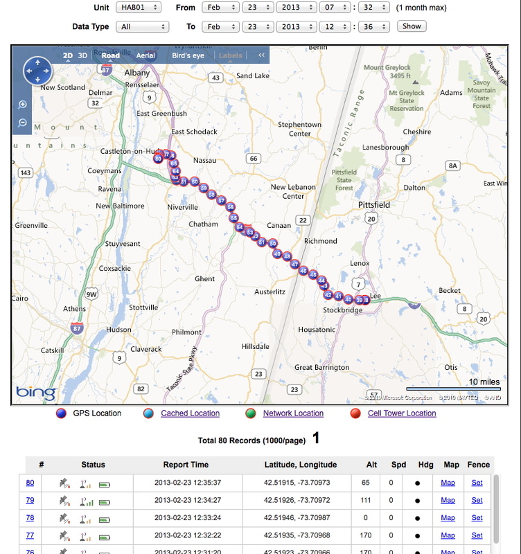
An important objective in this first launch was to estimate wind speed and direction versus altitude, and for that, a reliable radio tracker was needed. As APRS is a popular choice for high-altitude balloon flights, it was used as the primary radio tracker. The BigRedBee 2m HP GPS (high-power) radio with built-in GPS receiver was selected for SpaceCat-1 The callsign in use was KB1ZHX-1, and the BigRedBee was programmed to broadcast position every 30 seconds. The webiste aprs.fi was used to monitor packets received from the BigRedBee. Several screenshots from the APRS track are shown for the flight in progress:
While these messages could contain any type of information, one popular use of APRS is to pass position messages, typically generated by APRS stations with built-in GPS receivers. These APRS websites display position reports on a map, which makes APRS a convenient mechanism for tracking mobile APRS-equipped radios.
An APRS radio operates in an amateur-radio band, the most common being the 2 m amateur radio band., between 144 MHz and 148 MHz. (Of course, you need to be a licensed radio amateur to use 2m radio and APRS.)
An important objective in this first launch was to estimate wind speed and direction versus altitude, and for that, a reliable radio tracker was needed. As APRS is a popular choice for high-altitude balloon flights, it was used as the primary radio tracker. The BigRedBee 2m HP GPS (high-power) radio with built-in GPS receiver was selected for SpaceCat-1 The callsign in use was KB1ZHX-1, and the BigRedBee was programmed to broadcast position every 30 seconds. The webiste aprs.fi was used to monitor packets received from the BigRedBee. Several screenshots from the APRS track are shown for the flight in progress:

The initial portion of the flight path, showing ascent from the launch site. Each dot is an APRS position report - dots are spaced 30 seconds apart (but some reports may not be received/shown). The balloon immediately took a northerly heading, eventually transitioning to the northeast: this caused much worry as to a recovery in Northern Vermont.

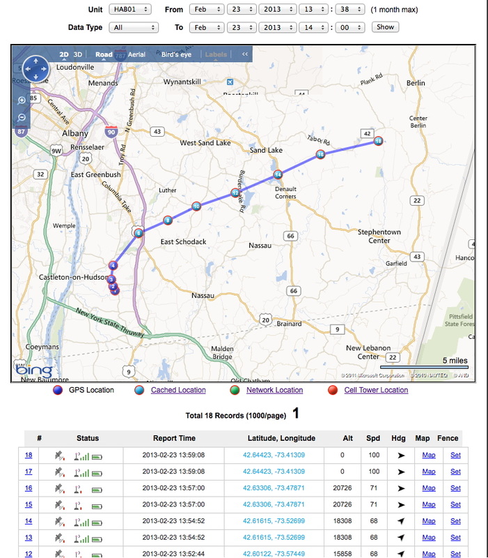
A bit later in the flight. The balloon is far up into the stratosphere at this point, approaching burst altitude. The balloon has taken a nice easterly track, heading into New Hampshire.

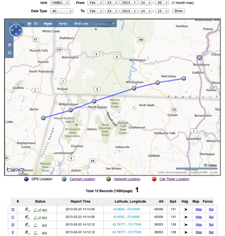
The balloon's flight path right up to and past burst. The closer spacing of the position reports indicates that the balloon is moving more slowly, suggesting very low wind speeds at burst altitude. Burst occurred to the east of Jaffrey, NH.

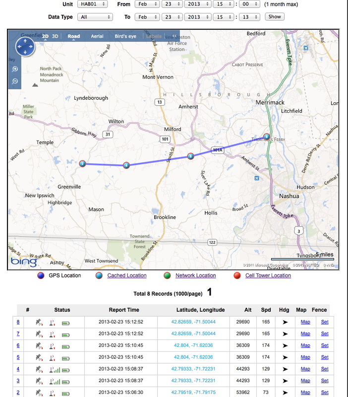
The balloon's descent to a soft landing, near Derry NH. The chase team was hoping that it would land in Canobie Lake amusement park . . . and it came very close!
APRS ALTITUDE REPORTS
One important note: the BigRedBee was programmed to report altitude in meters, which it faithfully did. However, the APRS reporting/website (and we're looking into how this happened) reported/displayed altitude in feet. The screenshot below shows the balloon within 500 m of burst altitude, just east of Jaffrey NH. One can see the altitude displayed in feet, when it was actually meters. This caused much consternation all around: it looked like the balloon was rising much too slowly . . . and it burst much too low . . . and it fell much too slowly . . . until this discrepancy was realised! (Shades of the Martian Climate Orbiter mistake.)

SpaceCat-1 reported altitude within seconds of burst. The correct altitude is 30,324 m.
CELL PHONE TRACKING
A secondary, or backup radio tracking system was also used, to provide another source of tracking data, and to help in spacecraft recovery. Selected from researching the success of other high-altitude balloon designs, this consisted of a cellular handset, specially-installed software on the handset, and an account with a tracking service. The software on the handset determines position (since many cellular technologies do just that to report position for E911 calls) and reports the position to a tracking service: for a subscription fee, one can monitor the handset on a website and download position data.
The service is provided by accutracking.com, and works over a range of cellular handsets and cellular network operators. Boost Mobile was chosen as the operator, for their coverage in the area and low cost (no contracts - pay as you go). A Sanyo Innuendo handset was selected as the handset model.
From prior testing, it was known that the handset would run for many hours on its internal battery, so this handset was turned on by the launch team during the drive to the launch site, to allow Tracking to keep tabs on progress. Here is the launch team driving towards the launch site, as reported by accutracking (the handset was turned on at the Lee rest stop westbound on the MA turnpike, I-90):
As with APRS, the cellular handset + accutracking.com service provided a reliable, steady track. Here is the launch and early rise of the balloon on accutracking.com. (Here, accutracking.com is reporting altitude in feet.) This graphic shows the balloon above 20,000 feet only 20 minutes into the launch. A caution: the speed estimates (from both systems) are not terribly accurate, due to how they estimate speed.
Despite other accounts of use of a cellular handset in a high-altitude balloon, this system reported faithfully up to approximately 50,000 feet! Beyond 50,000 feet altitude on the ascent, accutracking.com dropped out . . . but it appeared again on the descent at approximately 50,000 feet. Here is a graphic of accutracking.com reporting position and altitude above 40,000 feet on the ascent:
And again on the descent:
Another reason the cellular handset is used as a backup tracker is that will often perform more reliably near the ground than the APRS tracker. That is, if there are no APRS repeaters in radio reception range as the balloon nears the ground, the last reported position might be, say, 1,000 m up . . . and the balloon could drift quite a way in those last 1,000 m, which makes the chase and recovery more difficult. (Much more ground to search.) A cellular handset will likely work well right down to ground level, in most parts of the US: that's what cellular is all about. Here, we were fortunate in that APRS worked right down to the ground, as did the cellular handset.
LANDING SITE
Using accutracking.com, the resting spot of the spacecraft was reported to be a rural wooded area near Derry NH:

APRS tracking agreed with accutracking. The beauty of both systems is that, as they sit at rest, their preceived position tends to improve, as their internal GPS (or cellular location technology in the case of the cellular handset - usually a combination of GPS and other methods) estimation algorithm improves upon its location estimate. If all goes well, Tracking should be able to report an accurate position down to a resolution of a person's house, within 10 minutes of landing. Here, the landing site as reported by aprs.fi is shown:

CHASE TEAM
The predicted balloon landing site put it conveniently near SpaceCat HQ, and near major roadways, while also being clear of major urban centres (landing atop major power lines or very tall buildings were one of many insomnia scenarios for the Launch team). The actual landing site was very close to the predicted launch site, which was great news:

predicted landing site (prediction made on 21FEB)
|

actual landing site on 23FEB
|
The chase team set off within 15 minutes of landing, and arrived on-scene by 4:30PM. The landing report suggested the possibility of landing in an open field. It was close, perhaps 5 m from that field, but landed high up in a stand of pine trees, perhaps 12 to 15 m above the ground:

|

|
There the spacecraft remained - the story continues with the recovery team.
